Here is a presentation that I made as an educational piece for middle/high school age scientists. Please feel free to share and use this as an educational tool. I did not create any of the images used myself, and I'm using them under fair use. If you have any suggestions for additional presentations for educational use, I would be happy to chat with you - send me an email.
If you are having issues with the Embed above, you can find the presentation HERE
Monday, February 2, 2015
Book Review: Groundwater Around the World: A Geographic Synopsis

Book Review:
Groundwater around the World: A Geographic Synopsis
Overview
Hydrogeologists
work in a field that is evolving at the speed of science. That is to say that it comes in fits and
starts as important questions are addressed.
The release of an important work can have a major impact in the field
because as areas that are data poor are “filled in” the pace of additional
research can be accelerated. As
questions are answered, the scientific method is allowed to ask more related
questions, delving into additional realms of knowledge, and so it goes. Margat and van der Gun’s work here strikes me
as such a leap. Through this text a
great deal of education will take place, and because of the tone, pace, and
presentation in the book it is accessible to a great many people that may never
have been exposed to the material presented.
It is a rigorously scientific book, as evidenced by the references
section at the end of each chapter that often goes longer than two pages (for
the chapter!). But the presentation is
straightforward and made in a logical and psychologically appropriate way so as
to prime the reader to be able to follow the points made later in the text.
Rather than
presenting any significant piece of work itself (not to downplay the
aggregation that this book represents) I see that Margat and van der Gun appear
to have created an aggregation of the contemporary state of groundwater across
the world (including some new ideas) – arguably the most important spatial
extent for water resources. This reviewer
is not qualified to definitively say that there is no new material presented in
the book, in fact given the esteem that the industry has for these two
scientists, coupled with the amount of times that the authors appear in their
own references section it would appear that the authors have been at the
spear’s tip in the field, and have presented this book as a synthesis of
material, almost a moment of reflection designed to give the authors time to
“digest” the import of the material.
The Setup
The early chapters
serve to remind those not engaged in the groundwater field the basics of the
groundwater system. All of the necessary
primer material is included here, the Hydrologic Cycle, basic definitions of
groundwater and how it impacts distribution of water across the planet. Overall volumes of groundwater worldwide are addressed;
table 2.2 has estimates of groundwater reserves for various counties across the
world. This may seem rote initially, but
it speaks to an over-arching thesis that is not immediately apparent at the
onset of the book. The fact that
groundwater is distributed according to geological and hydrological forces, and gives no credence to artificial borders,
be they political, economic, or otherwise is a pervasive theme in the book,
and one that is expertly presented such that the reader is allowed to
synthesize it for themselves rather than having the text preach it to the
reader.
Further, Margat
& van der Gun don’t leave out the rigor that a student of the science
learns to require in a source. Specifics
are explored for each country, and a global context is presented that takes a
slightly familiar premise – that water resources are essentially being abused
worldwide – particularly by developed nations – and adds to the aggravator of
political and social contrivances that surround water because of its necessary
nature.
Moving Deeper
As the book
progresses into the middle chapters (starting with chapter 4); the authors being to intensify the
information toward the specifics of groundwater – more specifically why it is
considered a resource and how we go about exploiting it. Here they outline the “how” in their argument
by illustrating the various ways that humans interact with groundwater. The section on what they term “exploitation
strategies” was illuminating and one of the most important pages in the book
from this reviewer’s point of view.
Their sections on the various impairments seemed truncated, but this
isn’t the focus of the book after all.
The nature of some of the resources (renewable resources vs.
non-renewable, distribution, Access) by country is
explored, but only in short as it prepares the reader for future sections on
the topic.
Great care is
taken at the end of chapter 4 to illustrate the geographically (and otherwise)
diverse methods used for abstraction and this section is more dense than much
of the text as we, I guess, hit near the area of expertise of the authors.
Here is a great
time to mention the book’s use of full color photography. A number of typical wellheads are illustrated
in photographs and they are effective at illuminating the differences that,
this reviewer assumes, are geographically driven. This, combined with a series of wonderful GIS
based maps serve the topic well even when the authors themselves talk about the
pitfalls of maps early in the book.
Their comments about how maps illustrate only certain aspects of aquifers
(or their topic in general) is certainly true, but because the authors make
this point early in the text, the reader is inclined to trust the images that
the author has chosen more readily.
The Message
Chapter 5 is where
I consider the “message” of the book to begin in earnest. Here the authors examine the issues
surrounding the actual “use” of water in a geographic context. How much water can, and is abstracted from
various regions, the challenges each faces, and the purposes to which this
water is delivered. The authors cover an
incredible diversity of topics from irrigation, to bottled water and geothermal
uses. The chapter finishes with a look
at where the water is used by “sector” and the material presented supports much
of the reading this reviewer has done on the topic, but affords a solid base of
facts and figures to back it up. This
chapter unto itself is the most pertinent bit of reading that I did this term,
and I consider it one of the most influential sections of reading in my
education, not because it was the best written or most comprehensive (Thought
it was well written and comprehensive), but because it did so much in a
relatively small amount of pages. The amount
of topics covered well is astounding.
Also, the design and pace of the information as an aggregate makes it so
very digestible.
Concurrently,
chapter 5 begins to illustrate for the reader the pitfalls and dangers that
groundwater faces. Their vectors and how
common and banal the sources can be. The
stress here isn’t on “finger pointing” but rather how easy it is for
groundwater to be effected by human activity due, in part, to its nature as a
buffered “common property resource” as the authors put it. The authors give equal time to a number of
potential sources of impairment, such as “surplus of manure” & tillage practices
from agriculture and “exploiters of quarries…”.
But the largest single source of impairment discussed is the amounts of
extraction that occur above the natural flux of aquifers. This is discussed at length and with much
comparison of geographic specifics, primarily at the country level.
The “Solutions”
The remainder of
the book deals with the only tangible solutions to groundwater issues that
cross the aforementioned borders, political solutions via management
practices. The authors go to lengths to
set up a standard and objective, and then focus on the specifics of how
management can effect change on a cross border scale. This section is where the aggregation of
previous works really shines. The last chapter
acts as an encyclopedia of methods used in the groundwater field; covering
everything from political maneuvering to artificial recharge.
The Overall Conclusion
The water sciences
to the uninitiated may seem like a small scientific niche, this term has proven
that there is so much diversity in the field that the reading could go on
indeterminately. This book is a fitting
capstone to the endeavor of learning about groundwater – and one of the better
texts this reviewer has had the pleasure to read in more than six years of
scientific education. From the
perspective of an undergraduate on the verge of finishing a degree this book
allows the opportunity to “wrap up” the degree with a text that quite literally
addressed every aspect of what I have spent years studying, and managed to add
depth and breadth to my knowledge at the same time.
The geography of
groundwater is indeed one of the great challenges of our time. With conflict already common across many of
the geographic areas where water scarcity is an issue, understanding and acting
with purpose in relation to groundwater is a moral imperative that cannot be
overlooked and as more is understood about each spatially discrete watershed
and aquifer, we as water scientists have increased responsibility to work
toward a sustainable solution to each separate water issue that arises. Where there is use but no plan, a plan must
be developed. Where there is no source
but a resource exists, we must develop a manageable source. Where no resource exists, transfers and
additional techniques must be considered.
But with all of these, we must act according to the health, not only of
the stakeholders – but the health also of the watersheds and aquifers.
Saturday, August 31, 2013
The Lower White Salmon's Secrets
Much like the scientific community, the whitewater community often will surprise you with its boundless generosity and afford you an opportunity that you otherwise may have never had. This blog was started to satisfy a requirement for an undergraduate course I'm taking in Water Sciences - and I chose mostly to talk about the Deschutes basin as a general topic. However, during the course of the project Wet Planet Whitewater (www.wetplanetwhitewater.com) - a commercial rafting and kayaking company that I took my guide courses with - sent out an email blast looking for participants to give them feedback on the newly opened "lower" White Salmon river. They were going to take us down the entire river, and feed us lunch. For Free. All we had to do was fill out there survey at the end to give them feedback and help them determine if they are going to run this stretch of river commercially.
Let me just say that again...for free. Lunch included!
Needless to say, I was pretty happy to accept. This kind of full day trip usually runs over $100, and I already knew the company was a classy outfit.
So I signed up. Jenna and I showed up at the Wet Planet headquarters in Husum, WA at about 9:15 am after a good Americano and breakfast burrito in the charming hamlet of White Salmon. It was a bright day, promising heat like August does.
We suited up, and after the customary warnings, and instructions on how to not fall into the water - we hit the river. The first part of the day was the "normal" upper part of the river - which was amazing as always, but I really want to focus here on what amounts to one of the first ever commercial runs on the Lower White Salmon river - from Husum to the mouth of the Columbia River.
This run was only possible because of that happens in this fantastic video shot by Andy Maser for National Geographic
The destruction and removal of Condit Dam drained a lake and returned the White Salmon to its original form after nearly 100 years in captivity. After the sediment shifted, shifted again, and the morphology of the river settled, river runners began to venture into this new (old) landscape and portions of the river that had been underwater for 100 years were seen returning to their century old forms.
Getting to be part of the first commercial runs into this canyon was one that still strikes me as amazing. I feel very lucky indeed to have been a part of it, and the things that I saw are so consistent with the material that I have been exposed to at OSU in the water science and engineering program that I am beginning to feel that my choices have all lead to that moment.
We saw Steel bend, and just after Steelhead Falls. (pictured below). We saw...are you ready for this...salmon above the dam site, something that shows the resiliency of ecosystems. We saw waterfalls that nobody alive had seen. There was surprisingly little evidence of the dam itself, it seemed that PacifiCorp did a good job removing the dam.
I could post more images, but honestly I want to encourage people to go see it for themselves. Particularly those of you in the Geosciences, this is an opportunity to see an ecosystem in repair, both from natural services as well as remediation efforts. When/where will you ever have this chance again? There is no way to know!
At any rate, we finished the trip at the mouth of the Columbia and got on the bus to head back and fill out our surveys. I was honest about the trip, it was great, but the cost needs to be right and; I stressed this several times - they need to make clear the ecosystem issues that the river is facing and help people understand how unique it is to run a newly free flowing river. This was the part that was magic to me.
Let me just say that again...for free. Lunch included!
Needless to say, I was pretty happy to accept. This kind of full day trip usually runs over $100, and I already knew the company was a classy outfit.
So I signed up. Jenna and I showed up at the Wet Planet headquarters in Husum, WA at about 9:15 am after a good Americano and breakfast burrito in the charming hamlet of White Salmon. It was a bright day, promising heat like August does.
We suited up, and after the customary warnings, and instructions on how to not fall into the water - we hit the river. The first part of the day was the "normal" upper part of the river - which was amazing as always, but I really want to focus here on what amounts to one of the first ever commercial runs on the Lower White Salmon river - from Husum to the mouth of the Columbia River.
This run was only possible because of that happens in this fantastic video shot by Andy Maser for National Geographic
The destruction and removal of Condit Dam drained a lake and returned the White Salmon to its original form after nearly 100 years in captivity. After the sediment shifted, shifted again, and the morphology of the river settled, river runners began to venture into this new (old) landscape and portions of the river that had been underwater for 100 years were seen returning to their century old forms.
Getting to be part of the first commercial runs into this canyon was one that still strikes me as amazing. I feel very lucky indeed to have been a part of it, and the things that I saw are so consistent with the material that I have been exposed to at OSU in the water science and engineering program that I am beginning to feel that my choices have all lead to that moment.
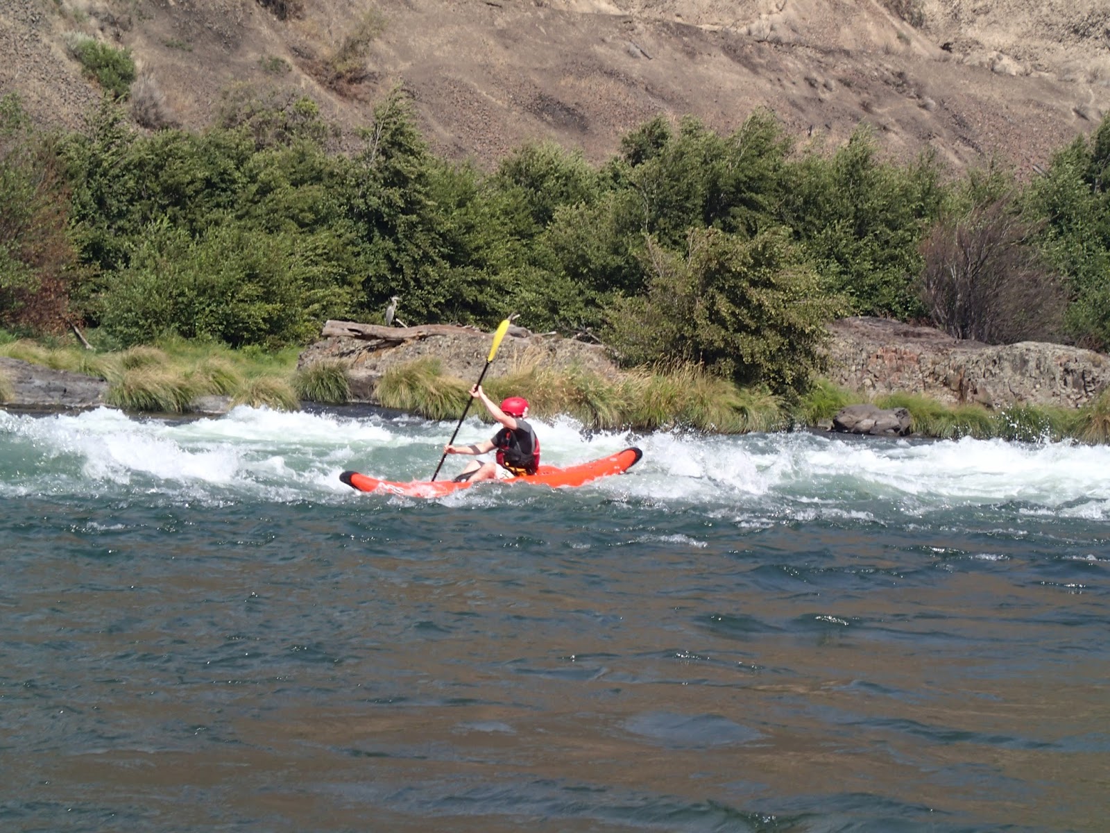
We saw Steel bend, and just after Steelhead Falls. (pictured below). We saw...are you ready for this...salmon above the dam site, something that shows the resiliency of ecosystems. We saw waterfalls that nobody alive had seen. There was surprisingly little evidence of the dam itself, it seemed that PacifiCorp did a good job removing the dam.
 |
| "Steelhead Falls Rapid" Image used courtesy Wet Planet Whitewater |
At any rate, we finished the trip at the mouth of the Columbia and got on the bus to head back and fill out our surveys. I was honest about the trip, it was great, but the cost needs to be right and; I stressed this several times - they need to make clear the ecosystem issues that the river is facing and help people understand how unique it is to run a newly free flowing river. This was the part that was magic to me.
Home Rivers
Home.
Its a powerful word that one...
It evokes something different for each person that hears it. For some it is a warm fuzzy; for others, not so much. When paired with the word river, the connotation is similar - but for whitewater enthusiasts, a home river is an important concept.
Home rivers are those that we find special for a reasons that we may not even be able to fully express in words. Its the comfort of knowing every inch of the run, knowing what it looks like (for the most part) in different seasons, knowing the stakeholders and their issues, knowing the wildlife and their patterns. These things are important parts of the whole of a river and each part has it's own issues.
I made a prezi to help outline some of the rivers that I love in the Pacific Northwest.
Monday, August 26, 2013
Using Prezi to "Leave No Trace"
We as modern students (regardless of our actual ages) have access to a wonderful array of tools to help capture the elusive "A". From my perspective of an older student, I recall the days when presentations often meant making a "poster" or some other banal visual aid - whereas we now have easy access to tools such as Powerpoint - and the "next generation" presentation software Prezi.
I'm sure many of you have already seen or used Prezi, but I made a presentation in an attempt to put a modern spin on an age old issue. Aldo Leopold may not know how to boot up a PC, but I think he would approve of this message.
Watch it in full screen by pressing the button on the far right bottom.
Sunday, August 25, 2013
Riviere aux Chutes: A brief history
Give Back to the River You Love - 2013 Button Campaign from Deschutes River on Vimeo.
As a student and full-time worker, I am often pulled in a number of conflicting directions. Life roles are often purely dichotomous, with little overlap. When situations are like this, stress creeps up to the forefront and often becomes a significant issue. Sometimes..just sometimes my roles (student, Benefits professional, and whitewater enthusiast) overlap in ways that I just never anticipated.
Work & Play Intersection
As part of a project for Oregon State University's GEO 335 course, I did some research into the Deschutes basin. This was fortuitous because I had already planned to do a multiday rafting trip on the Deschutes, before the class had even begun. This overlap was a welcome addition to my summer, it allowed me more room to excel at both of my goals; get an "A" in a required class - and have a fulfilling summer vacation; and exciting proposition for me. Especially since my summers have been very busy for the last few years.
Riviere aux Chutes
The Deschutes River and its related basin are a fixture in the hearts and minds of native Oregonians. As one of the major tributaries to the mighty Columbia, few other rivers have as much socio-economic import than the Deschutes. Early french trappers called the river Riviere aux Chutes - or river of falls which was apt because the river had a gradient over its length that supported a great many falls and rapids. The river was wild and unpredictable flooding the area each year during spring runoff and precipitation events.

Life flourished on the banks of the river and there is evidence of populations on the Deschutes at least 9000 years ago. Petroglyphs and early native camps can still be seen on reaches of the river today. These people flourished for generations until about 7000 years ago when mount Mezama (current day Crater Lake) and mount Newberry began erupting on a frequent basis, burying much of central Oregon under a 10 foot blanket of ash. Forcing people to make the difficult crossing to the western part of the State - over the Cascade mountains. During this time, the Deschutes and related tributaries ran thick with ash and did not support the large diversity of life that we now associate with the river basin.
5000 years ago volcanic activity began to slow, and the Deschutes basin began a return to its productive regime. With this increase in productivity the native people began to return to the central part of the state for the warm climate and returning game. Things would remain good and stable until the early 1800s when early trappers began making contact with the native cultures. This was a harbinger of big changes to come.

With the increase in the economic interest in the Central Oregon plateaus, western migration began in earnest. Manifest Destiny saw rivers as a goldmine of sorts, providing valuable water but also acting as a barrier to movement. This duality would stand as an issue until the early part of the 20th century when manifest destiny took a major leap forward and began the systematic damming of large rivers across the west.
The Deschutes was free flowing until 1922 when the Bureau of Reclamation built a series of dams to provide irrigation for, what was to that point, a parched and arid land.

This irrigated land provided one of the few missing elements for Central Oregon to support larger populations centers, ready availability of water for irrigation and drinking. This combined with the series of navigable reservoirs that created regular flows for recreation opportunities on the river as well as in the reservoirs themselves and its easy to see why the population of Central Oregon grew faster than any other part of the state in the middle part of the 20th century.
Native Inhabitants
The treaties of 1855 (and others in that general time span set forth rules on harvests for fisheries on the Deschutes. These benchmarks, combined with the establishment of the Warm Springs Indian Reservation in the same treaties changed many of the uses of the river, often for the better. The nations on the reservation take seriously their role as stewards of the river and often lead the "charge" to keep rivers well managed.
The new way of thinking
The American line of thinking as it relates to natural resources has undergone significant changes since the early part of the 20th century. Big thinkers like Aldo Leopold and John Weir changed the public's way of thinking about natural places. With this change in mindset came a desire to reserve these wonders for future generations. This noble notion continues today, mitigated by the need to use the water resources for the furtherance of the existing populations. You can see this type of mindset in some of my other posts, especially relating to the "Leave No Trace" ethic. The LNT folks love to quote Aldo Leopold.
The Future of the Deschutes
Use of the Deschutes river has never been higher. According to the Prinevill BLM, more than 50,000 people use the Deschutes for recreation during the summer busy season. These are only the users that need to have interaction with the BLM that are measured. Usually those that have to seek a permit or license for their use; such as Rafters, Kayakers, anglers, and campers. Many users go uncounted altogether, such as those that use the trails on either bank of the river, those that day trip to the river to swim and those that come to take photographs.
Use is likely to increase, and with this use comes the challenge of engaging stakeholders to enable the most use, with the least impact. This methodology is exactly why I am in the water science and engineering program at OSU. I feel like having people that care about the watersheds, but that have a solid understanding of the interplay between stakeholders by way of scientific rigor, will lead to the best end result possible.
Here is to making a difference.
Saturday, August 24, 2013
Leaving No Trace in the Deschutes Wilderness

Floating on a River
So my ladyfriend and 13 of my closest friends (was supposed to be 15, but we had to last minute cancellations) rafted the "lower" Deschutes river recently. It was an amazing trip and the pictures bear this story out, but one really important thing presented itself as a challenge. Leaving No Trace.
Many of you may already be familiar with the Leave No Trace ethic. At its heart it is a wilderness ethic that aims to educate people on how to make use
The Deschutes releases thousands of permits for river use each year and the Prineville BLM estimates that 50,000 people use the river each summer (the peak season). The Deschutes is over 250 miles long, but if we just use the places where use concentration is highest (Harpham Flats to Sandy Beach takeout) which is 13 miles - the damage that could occur if just on-in-ten of the 50,000 people that use the river dig a cat-hole is staggering.

Ewww Pooooo
According to a recent study on the topic (yes, I looked it up), the average American's stool mass is 225 g - or about half a pound of poo. If 1/10 of the 50,000 visitors left a cat hole with poo in it this would amount to 2500 pounds of poo - OVER A TON OF POO. Now, a ton of poo wouldn't be that much of an issue if it were spread over a large area, but river use limits the area over which the application happens, we are really only talking about the Riparian area. So if we take the 26 total riparian miles (13 miles of river X2 opposing banks) we see that this means ~96 pounds of poo per bank mile. Gross.
Back on topic!
Anyway, enough poo talk, Leave No Trace aims to help us use our wild places responsibly while protecting it for use by others. More on the specifics of Leave No Trace in another Blog; what I really want to talk about is some of the challenges that we faced on the Deschutes trip.
As we camped at the put in, talking excitedly about rapid names, and which campsites we wanted to stay at on the river, we drank beer. It was hot - even as the sun set - and the beer was cold coming out of coolers that not only had ice, but DRY ICE (solid CO2 - much colder than solid water), so it was ice cold and refreshing. There were several kinds of chips, salsa, pretzels, and even some homemade strawberry shortcake.
At the put in, before you launch your raft trip, is the perfect time to indulge because anything you eat now, can be bulky or heavy, anything you eat on the trip has to be expertly packed into dry boxes and coolers meaning that there are limitations to what you can take. So we indulged..
When we awoke, slightly hung over and very excited to get the boats rigged and get underway; there were a number of things that struck me in regards to the Leave No Trace Ethic.
1. We had left food out all night. While it was contained and not strewn all over the place, this afforded wildlife an opportunity to eat foods that weren't meant for them. They easily could have made a mess, that would have been counter to the leave no trace ethic. This was a little bit disheartening to me as I simply didn't think of it.

2. Our tents, most of which were set up in the dark, were haphazardly placed - some flattening vegetation (sage mostly). This is anther "no no".
3. Our beverage containers were everywhere, and the campground doesn't have recycling. In order to really adhere to leave no trace, these containers are going to have to come with us on the river - which they did.

Before we launched, before we even rigged the boats, I coordinated a cleanup of our campsite that included making sure the sage plants that were trampled during out stay were re-erected (sage is actually very resilient), we also handed out some Leave No Trace materials to other campers, most of whom were in RVs and oblivious to the impact they were having.
I guess this post is meant mostly as a reminder that the idea of conservation is one that is not yet fully integrated into our way of life. It is still something that has a completely mechanical and rote application process. It doesn't just happen, no matter how good your intentions. It is and additional layer of work. It takes coordination, education, and follow through.
I distinction remember thinking that this was totally worth it as we shoved off into the river and looked back toward our primitive campsite and saw...desert.

Subscribe to:
Posts (Atom)